The role of the ice ages in the dispersal of the genus Phelsuma.
01/07/03 13:39 Filed in: Biogeography
Gondwana began to break up during Late Triassic to Early Jurassic time. Major mantle plumes such as the Karoo-Ferrar Plume that first split Gondwana at about 182 Ma, the Paraná-Etendeka plume at 132 Ma that split South America and Africa, the Marion plume at 88 Ma that split Madagascar and India and finally the Reunion hotspot that split the Mascarene Plateau from India at 64 Ma.
The separation of the Mascarene Plateau was accompanied by a tremendous outpouring of basaltic lava from this hotspot, giving birth to a mass of igneous rock called the Deccan Traps, which today covers much of western India. Because the Mascarene Plateau was just beginning to separate from India at the time, much of this basalt covers the plateau as well, though the eruptions did not smother all of the older granite.
Some of the granite remains still above sea level, forming the granitic islands of the Seychelles, located in the northern tip of the Mascarene Plateau. While the plateau drifted northwards over the Réunion Hotspot a series of now submerged islands were formed. This process started 64 Ma, after the separation of the Mascarene Plateau and India, about 35 Ma the Saya de Malha bank was formed, later the Nazareth bank and the Cargados Carajos Shoals (Saint Brandon). Cargados Carajos today still counts 22 small islands. About 7 Ma the northern islands of Mauritius and Mauritius itself where formed. Reunion only reached the surface about 2 million years ago, and is the youngest island originating from the Réunion Hotspot.
The Mascarene Plateau now extends approximately 2,000 km between Seychelles and Mauritius and is one of the few submerged features clearly visible from space. It covers an area of over 115,000 km² of shallow water with depths ranging from 8 m to 150 m on the plateau, plunging to abyssal depths of 4000 m at its edges. It is granite at its core, with a mantle of basalt and limestone.
The limestone banks found on the plateau were once coral reefs, indicating that the Mascarene Plateau once formed an archipelago of islands much bigger then Mauritius or Réunion today. Erosion, subsidence and sea level fluctuations made the islands disappear.
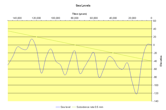
Over time there has been a continuous change in sea levels due to periods of glaciation near the poles (ice ages) that determined the climate and sea levels on earth. The last of the ice ages reached its maximum roughly 18,000 years ago, and then gave way to warming. Sea level rose rapidly between 18,000 and 6,000 years ago (about 130 m) , drowning almost the entire Mascarene Plateau. Today only a few areas remain un-submerged forming the islands of Saint Brandon, Albatross Island and some offshore islets near Mauritius (incl. Round Island). The rest is submerged, large areas by only about 10-40 meters below current sea level.
Plate tectonic processes like subsidence, subduction and sea-floor spreading are not to be neglected even if they occur on much longer time scales than glacial cycles. If the subsidence rate of the plateau is only 0.5 mm per year then the plateau never has been submerged during earlier sea-level fluctuations. (see graph)
Even during the ice ages, average temperatures in the area were only 1° to 3° C lower than today. It is thus very likely that some, now submerged, islands of the plateau were inhabited by the genus Phelsuma. The morphology of the current Mascarene species indicates an early dispersal from Madagascar. The young age of Mauritius does not suspect this, meaning that the ancestor of the Mascarene forms probably used the islands of the Nazareth bank and the Cargados Carajos Shoals as stepping stones to colonize in a later stage Mauritius.
Some of the granite remains still above sea level, forming the granitic islands of the Seychelles, located in the northern tip of the Mascarene Plateau. While the plateau drifted northwards over the Réunion Hotspot a series of now submerged islands were formed. This process started 64 Ma, after the separation of the Mascarene Plateau and India, about 35 Ma the Saya de Malha bank was formed, later the Nazareth bank and the Cargados Carajos Shoals (Saint Brandon). Cargados Carajos today still counts 22 small islands. About 7 Ma the northern islands of Mauritius and Mauritius itself where formed. Reunion only reached the surface about 2 million years ago, and is the youngest island originating from the Réunion Hotspot.
The Mascarene Plateau now extends approximately 2,000 km between Seychelles and Mauritius and is one of the few submerged features clearly visible from space. It covers an area of over 115,000 km² of shallow water with depths ranging from 8 m to 150 m on the plateau, plunging to abyssal depths of 4000 m at its edges. It is granite at its core, with a mantle of basalt and limestone.
The limestone banks found on the plateau were once coral reefs, indicating that the Mascarene Plateau once formed an archipelago of islands much bigger then Mauritius or Réunion today. Erosion, subsidence and sea level fluctuations made the islands disappear.
Over time there has been a continuous change in sea levels due to periods of glaciation near the poles (ice ages) that determined the climate and sea levels on earth. The last of the ice ages reached its maximum roughly 18,000 years ago, and then gave way to warming. Sea level rose rapidly between 18,000 and 6,000 years ago (about 130 m) , drowning almost the entire Mascarene Plateau. Today only a few areas remain un-submerged forming the islands of Saint Brandon, Albatross Island and some offshore islets near Mauritius (incl. Round Island). The rest is submerged, large areas by only about 10-40 meters below current sea level.
Plate tectonic processes like subsidence, subduction and sea-floor spreading are not to be neglected even if they occur on much longer time scales than glacial cycles. If the subsidence rate of the plateau is only 0.5 mm per year then the plateau never has been submerged during earlier sea-level fluctuations. (see graph)
Even during the ice ages, average temperatures in the area were only 1° to 3° C lower than today. It is thus very likely that some, now submerged, islands of the plateau were inhabited by the genus Phelsuma. The morphology of the current Mascarene species indicates an early dispersal from Madagascar. The young age of Mauritius does not suspect this, meaning that the ancestor of the Mascarene forms probably used the islands of the Nazareth bank and the Cargados Carajos Shoals as stepping stones to colonize in a later stage Mauritius.